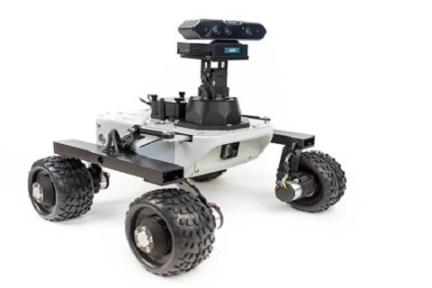
UGV ROVER
GMR’s Complete Unmanned Ground Vehicle radiation mapping system
The radiation mapping rover gives you real-time location measurement and mapping of radioactivity with isotope identification using a small ground vehicle
...
provides a ground-based metre resolution maps of radiation levels. The UGV radiation mapping rover allows routine and repeated monitoring of site areas to rapidly provide data to highlight anomalous changes in radiation and its spread related to nuclear incidents or nuclear transport accidents. When deployed for site surveys on unmanned vehicles, because the operator remains at a remote distance, the Rover effectively reduces worker exposure to radiation. The payload bay contains either one or two gamma spectrometers and positioning devices utilising custom-built software to combine radiation intensity and geolocation data to produce maps of radiation levels and identification of isotopes present.
Using the Rover you can rapidly collect radiation data with excellent sensitivity and isotopic fingerprinting.
The Rover can be pre-programmed for autonomous area surveys.
2. UGV radiation mapping rover detector unit and payload bay :
Multiple gamma spectrometers can be connected to the Rover and work simultaneously.
3. Gamma spectroscopy and mapping software :
The software shows CPS and location, CPS over time, energy spectrum, dose estimation and isotope characterisation. Giving you a picture of the radiation spread over an area.
Size
Weight: 6,5 kg
Dimensions: 410x460x270 mm
Payload capacity: 5 kg
Upper platform mounting dimensions
Dimensions: 299 x 183 mm
Hole grid: 18 x 15 mm
Holes: 40 x Φ 7mm + 22 x Φ 5,5mm
Performance
Estimated maximum obstacle size: 70 mm
Protection rating:
complies with IP66 (not certified)
Run time: Estimated 4 hrs of nominal driving
Connection range: Up to 100m (with live video stream)
Wheels
Motors: 4 x in-hub DC motor with 73.2:1 planetary gearbox and 12 CPR encoder
Wheel diameter: 130 mm
Tire material: rubber with foam insert (non-pneumatic)
Battery
Voltage: 11.1 V DC
Capacity: 5000 mAh
Type: Li-Ion with internal PCM
Short-circuit, overcurrent and overdrain safety features
Max. current: 8A (total for the whole Rover)
Speed
Max. linear speed: ca. 0.4 m/s
MAN TO MARS ROVER
The Man To Mars Rove with Pincher AX-12 Robot Arm is a 4 degree-of-freedom robotic arm with different optional mounting plate and cable adapters Pincher Robotic Arm
Weight : 550GVertical
...
Reach : 35CM Horizontal
Reach : 31CMS trength 25CM/40G20CM/70G15CM/100G Gripper Stength500G HoldingWrist Lift Strength 250G
• Solid Needle Roller Bearing Base
• Rugged ABS construction
• Arbotix Robocontroller for Onboard Processing
• Custom Parallel Gripper
• Mounting Brackets for Cameras & Sensors
GMR’s M4 UGV
Get the job done - In any weather, without special FAA licensing or troublesome airspace restrictions.
The M4 is a rugged, commercial grade, highly capable UGV designed for Commercial, Agricultural and Research applications.
Built from Aluminum, featuring a modular top deck and ultra high strength polymer components, the Model M is engineered to thrive in rugged outdoor use.
The chassis weighs close to 30lbs(13kg) and rolls on special 9.6"x5.5" flotation tires that provide excellent traction and important shock protection for your sensitive electronics.
MAN- TO -MARS class of GMR ROVERS are designed in a Mars- environment through various runs to accomplish complex tasks
These tasks involved traversing rough terrains, carrying payload to remote locations, servicing a complex control panel, and analyzing collected soil samples. During every run, the teams were expected to wirelessly operate their rovers on more than 1 kilometer and continuously rely on sensor feedback provided by the on board MTS s, GPS, cameras, and scientific instruments.
Best Run for the Blind Navigation Task
The precision of the BTN singlehandedly allowed for the blind navigation task, in which to navigate to GPS coordinates in a hard terrain without using cameras. The device allowed us to immobilize ourselves 20 centimeters away for the last waypoint, after over 500 meters of blind navigation, which had never been.
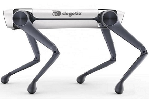
GMR ROVER DOG SALTY
SALTY is Capable of navigating , surveillance and mapping
ROVER DOG SALTY is an agile mobile robot that navigates terrain with unprecedented mobility, allowing you to automate routine inspection tasks and data capture safely,
...accurately, and frequently.
Equipped with 3D Virtual Operations Center that allows personnel to remotely operate semi-autonomous legged UGVs (unmanned ground vehicles) for security patrols in real time. The operations center provide area maps as well as real-time video streams and sensor feeds. ALTY can be used to capturing data to monitor the progression of a project, particularly when obtaining data from restricted or dangerous areas equipped Salty with a 360° camera to allow it to capture completed work on the jobsite.
The integration allows the site manager to compare weekly or even daily images in order to track the site’s progress. These images can be compared to the 3D model to visually identify any differences, aiding in the coordination of on-site subcontractors and trades people.
Salty can be trained by an employee of the Innovation team to follow a specific path with Salty has been programmed to autonomously take pictures on a regular basis from repeatable locations outside of work hours, requiring intervention only for battery swaps predefined locations where photo capture is required
The robot dog SALTY is controlled through tablets, desktop computers or virtual reality.
CONSTRUCTION
Inspect progress on construction sites, create digital twins, and compare as-built conditions to Building Information Modeling (BIM) autonomously with Salty . & GAS
Create autonomous routes or drive the robot to remotely inspect facilities and improve awareness of plant operations.TILITIES
Create autonomous routes or drive the robot to remotely perform inspections in electrified or radiation dense areas